Document Actions
SIGAve
Regional geographical information system
INESC TEC modernises the local administration structure with a centralised and regional geographic information structure which supports management activities and development of the territory of Vale do Ave.
Geographic based products and spatial management databases play an influence on the decision made by Public Administration and Policy Planning, at Local, Regional and Central. In this sense, INESC TEC promotes the modernisation of local management structure with a centralised and regional geographic information structure, which supports management activities and the development of the Vale do Ave region.
The spatial data infrastructures are assumed to be the mode of excellence to create, distribute and use geographical information, using the Internet and interoperability concepts and services based on this model. Moreover, the current state of development of free tools (Open Source) makes it possible to develop these infrastructures with degrees of reliability and functionality at least equivalent to owner infrastructure/software.
INESC TEC’s Centre for Information Systems and Computer Graphics (CSIG) acquired a set of skills in Geographic Information Systems (GIS), particularly in the area of GIS interoperability in, and has been conducting activities in the Central, Regional and Local Governments in order to support Administrative Modernisation providing strategic consulting and developing new services and applications. In this context, the Sigave thus responds to the challenges posed by the specific requirements of the Public Administration, providing a tool that places and manages geographic centralized and regional information, from multiple data sources, facilitating the integration of dynamic spatial data and contributing to the modernisation of the administrative region of Ave.
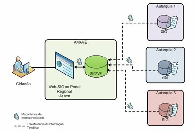
The SIGAve thus constitutes a platform for visualising and managing geographic information, with two-way communications between the Association of Municipalities of the Vale do Ave and Partner Municipalities, which allows for greater and more effective strategy for updating and exchanging data within the Sub-Regional Ave region, thereby enabling support management activities and the territory’s development.
Paying attention to the different realities of Local Authorities in terms of GIS infrastructure, the Sigave defines a data model and a common rating to all areas of the Sub-Regional Ave (Region and Municipalities in the Vale do Ave), in addition to standardising and enforcing standards for geo-referenced information (Open Geospatial Consortium standards).Using standardised protocols and formats thus contributes to their widespread use, allowing geographic information to be shared easily and freely without any restriction.
At the same time, and as required by the directive INSPIRE (Infrastructure for Spatial Information in the European Community) establishing an Infrastructure for Spatial Information in Europe, the Sigave promotes a connection between the Vale do Ave regions using interoperability mechanisms between Municipal GIS and the Sigave Platform to produce and disseminate spatial data, allowing a true economy of scale and increased supply of services to the citizen.
Project Leader: Vard 2015 (Vale do Ave Digital Region) - AMAVE (Association of Municipalities of Vale do Ave)
Partners:
- Municipality of Cabeceiras de Basto
- Municipality of Fafe
- Municipality of Guimarães
- Municipality of Mondim de Basto
- City Council of Póvoa Lanhoso
- Municipality of Vieira do Minho
- Municipality of Barcelos
- Municipality of Vizela
Contact: Lígia Silva
